Geospatial Augmented Reality

SmartCam3D® situational awareness software provides geospatial augmented reality overlays on live video at 30+ frames per second.  This technology originally served as the primary flight display for the NASA X38 during initial unmanned testing and today is deployed with US Army Tactical Unmanned Systems as a module within the Universal Ground Control Stations used in conjunction with the Hunter, Shadow, and Gray Eagle UAV Platforms. Additional integrations of this technology include EO/IR Gimbals, sUAS Pilot Applications, a plugin for the Android Tactical Assault Kit (ATAK), and a comprehensive Mission Management Application for the manned ISR market.

Situational Awareness

SmartCam3D® provides enhanced situational awareness to a variety of stakeholders and end-users throughout the ISR ecosystem – from the front-line to the Operations Center. By blending geospatial data like the location of roads, boundaries, and Points of Interest, with live video, SmartCam3D® empowers the viewer to make better decisions – making operations safer and more effective.  With the ability to overlay nearly any entity with a geographic context (e.g. Latitude/Longitude/Elevation), on live, full-motion-video, SmartCam3D® provides a data-rich and -recent operating picture, lowering task-difficulty and preventing cognitive-overload during mission execution. 

SmartCam3D® Addresses
Key Pillars of Situational Awareness

"Situational Awareness is the perception of environmental elements with respect to time and/or space, the comprehension of their meaning and the projection of their status in the future."

perception

Without Perception, operators are missing valuable information within the operating environment. A 2005 study by the Air Force Research Laboratory confirmed SmartCam3D® significantly improved sensor operator target acquisition time while simultaneously lowering task-difficulty by providing GIS information as augmented reality overlays on live video.

projection

Without Projection, an operator lacks the ability to project, or forecast, how circumstances may change over time. SmartCam3D® combats this by providing a data-rich operating picture, with the most up-to-date GIS information, allowing users to collaborate with colleagues and better forecast how the operating environment will evolve over time.

comprehension

Without Comprehension, an operator may perceive all the elements within the operating environment, but due to high cognitive-load, struggle to comprehend all the data-points appropriately. SmartCam3D® combats this by supplementing FMV-feeds with important GIS data, thereby allowing sensor operators to manage more targets at one time and enhance situational awareness.

execution

The utilization of SmartCam3D® enhances situational awareness among sensor operators - and other mission viewers - by supplementing FMV-feeds with geospatial data. This combines the benefits of full-motion-video and geographic information display, which is typically discerned from two separate data displays. This promotes efficient and effective mission execution.

operating system COMPATIBILITY

SmartCam3D® is compatible with Android, iOS, Linux, and Windows operating systems.  To learn more about SmartCam3D®, please download the informational sheet below or request sample code by completing the linked form.

Smart Video

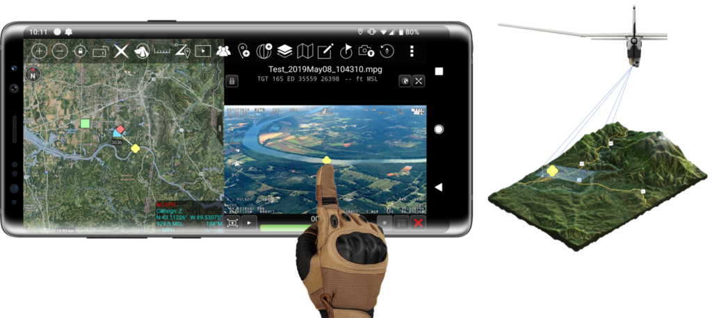
SmartCam3D® leverages metadata embedded within MISB-compliant video-streams, or reported directly from flight controllers or sensor payloads, to superimpose geospatial augmented reality overlays on live video. This allows the SmartCam3D® module to display nearly any entity with a geographic context.  Additionally, SmartCam3D® allows users to interact with live video in the same ways they would a 2D-map display. For example, users can drop a pin to mark a geospatial location in the video, perform forward- or reverse-geocoding, or leverage a patented capability from Rapid Imaging known as Cross-Cuing.  Furthermore, if the sensor payload is adequately-equipped, additional patented capabilities having to do with measuring from live video, are possible. 

Features

SmartCam3D® provides a variety of features, namely, GIS overlay display control, GIS overlay aesthetic control, Pin Dropping, Geocoding, and Cross Cuing. 

Geospatial aR

SmartCam3D® provides geospatial augmented reality overlays on live video and combines the benefits of both a 2D map display and a Full-Motion-Video display into a single operating picture.

Overlay Aesthetic

SmartCam3D® provides overlay aesthetic control  allowing end-users to individually select which GIS overlays they want to see. Additionally, users can leverage metadata offset controls to adjust Heading, Vertical Field of View, Altitude, and Pitch. 

Drop a pin

SmartCam3D® allows end-users to drop pins within the live video.  Due to the fact SmartCam3D® understands the physical location (e.g. Lat/Long) associated with each pixel in the video frame, this Point of Interest can then be shared as a physical location on Earth and displayed on a map.  

cUSTOM gis iMPORT

SmartCam3D® allows end-users to import custom GIS data and display it on live video.  Tools like Google Earth can be used to create Points of Interest, Lines, Polygons, and more and then imported via various formats (e.g. .kmz).   

GEOCODING

SmartCam3D® offers a powerful Geocoding capability allowing users to designate a point in the video and immediately receive the geospatial data associated with that point on Earth.  Forward- and Reverse-Geocoding are supported, allowing users to convert location text into geographic coordinates (Forward-Geocoding) or convert geographic coordinates into place names (Reverse-Geocoding).   

cROSS CUING

SmartCam3D® includes a patented capability from Rapid Imaging known as “Cross Cuing.” Cross Cuing allows end-users to touch or drag their cursor anywhere on the live video and see a reactive/representative cursor on their 2D map display (or vice versa).

PREVIOUS INTEGRATIONS

SmartCam3D® has an impressive performance history going back over two decades.  Check out our previous integrations below.

fLIGHT dISPLAY

x38

NASA X38

unmanned testing

gEOSPATIAL AR

Army UGCS

2002-Present

GEOSPATIAL ar

SC3D ATAK

2019-Present

ISR MISSION MANAGEMENT

LandForm®

1995-Present

GEOSPATIAL AR

SDKs

Android/iOS/linux/windows

OBSTACLE VERIFICATION

SmarTopo®

Phase i-iii sbir | nasa/faa