Streamlining Inspection Workflows

Aerial Inspector is a sUAS Pilot application that provides a highly configurable and customizable infrastructure inspection platform. By incorporating traditional infrastructure inspection workflows into streamlined mobile or drone-based collection applications, Rapid Imaging provides end-users actionable intelligence on referenced assets in an organized format as compared to traditional data collection and reporting methods.  Aerial Inspector has been specifically designed to collect, organize, and upload pertinent information relating to infrastructure assets in a variety of industries. 

Build to Suit

Aerial Inspector is a customizable sUAS Pilot Application. This means the UI/UX is specifically formatted for each end-user based on their use case (e.g. Bridge Inspection, Distribution Pole Damage Assessment, Telecommunications Inventory Inspection, etc.).  The Aerial Inspector Platform allows end-users to upload their aerial inspection workflow and then see it as an inspection option within the app when they are logged-in.  This is done by translating the steps, pre-inspection questions, photos, follow-up questions, measurements, and post-inspection questions into a custom inspection workflow that populates the app with a step-by-step guide for the drone pilot to execute. 

Infrastructure Inspections

Adaptive

Aerial Inspector is adaptive to a variety of infrastructure inspection use-cases. End-Users are able to develop their own custom inspection workflows and see them in the app as step-by-step guides for the drone pilot to execute.

Organized

Aerial Inspector organizes all captured data throughout the inspection. Typically, this data is formatted into a JSON, which can be uploaded to a variety of back-end database solutions. Alternatively, the app is capable of writing inspection data into Photo EXIF fields. This allows personnel to search or sort photos based on desired criteria, such as the Asset ID, the component being inspected, or the severity-level of the problem identified.

Configurable

The Aerial Inspector app is highly configurable, allowing end-users to input a variety of inspection steps including: Pre-Inspection Steps, Photo Steps, Follow-Up Question Steps, Measurement Steps, and Post-Inspection Steps.

Uniformity

Aerial Inspector brings standardization and uniformity to an inspection workforce and their associated inspection reports. By pre-configuring inspection workflows, enterprise customers can ensure each inspector uses the same terminology and final reports are consistent regardless of whether the inspector is highly-experienced, brand new, employed by the company or working as a sub-contractor.

operating system COMPATIBILITY

Aerial Inspector is in beta testing on Android and iOS.  To inquire about joining the beta test, please click on the sign-up buttons below.

Step-by-Step Inspections

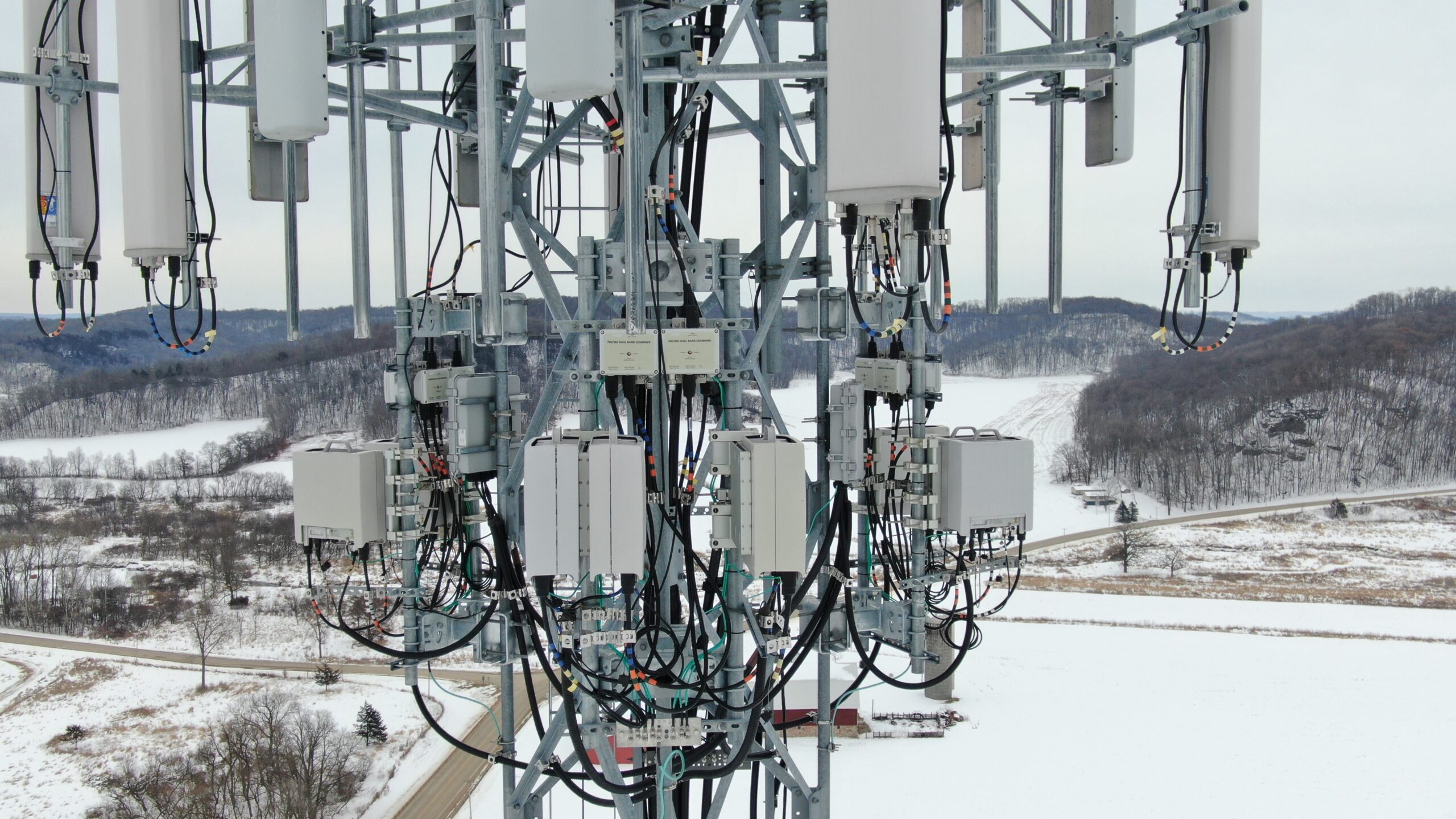
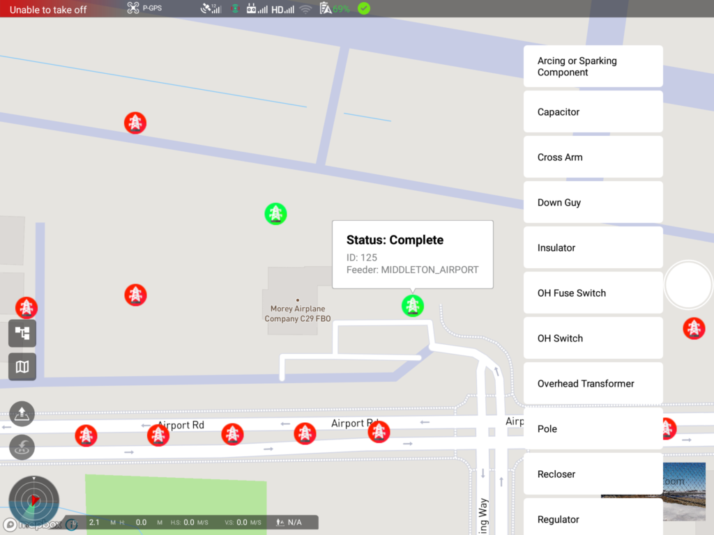
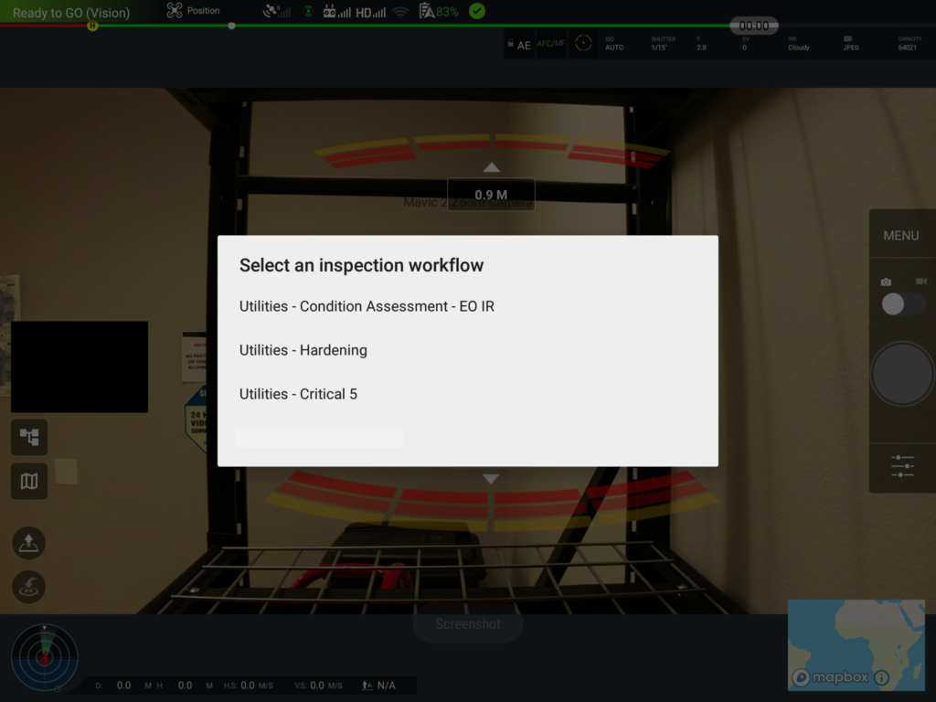
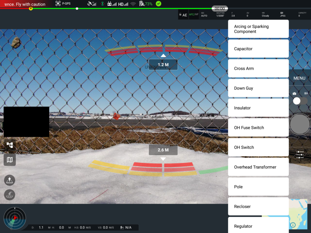
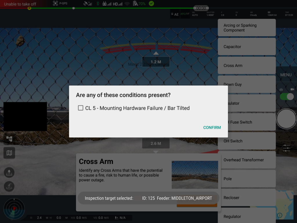
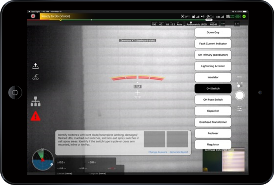
The Aerial Inspector App provides step-by-step workflows for sUAS Pilot Inspectors.  The app ensures all inspectors follow the same inspection process, capture all the necessary photos, and answers all the required questions relating to the inspected infrastructure asset. The app provides many benefits, including: the ability to add new inspection workflows on-demand, the ability to continuously manipulate existing workflows to meet regulatory requirements, the ability to more significantly leverage airborne inspection platforms, the ability to accelerate the reporting of highly-critical, actionable intelligence, the ability to automate inspection processes, the ability to standardized inspection processes across the workforce, and the ability to train new inspectors while increasing efficiency of experienced inspectors.

Use Case Deployments & Features

Rapid Imaging developed Aerial Inspector to streamline infrastructure inspections when leveraging small UAS. Check out our previous use-case deployments and the features of the App below.

Aerial Inspections

Power-Lines

Energy

dAMAGE aSSESSMENT

Aerial Inspections

Telecom

Inventory

Asset-id mATCHING

Aerial Inspector can provide automatic Asset-ID matching to a database if provided with the appropriate information, such as the Asset-ID and location (e.g. Lat/Long). This is done using a proximity algorithm and the geospatial data coming from the sUAS. 

Pre-Inspection Questions/Answers

Aerial Inspector supports “Pre-Inspection” questions and answers. These questions are often utilized to capture pertinent information prior to the inspection, such as the Inspector Name, Asset Composition, etc. The answers to these questions are bundled into the JSON or stored in the EXIF data of the captured photos.

Photo Steps

Most Aerial Inspector workflows include a pre-designated shot-list. Typically, each required shot corresponds with a component on the Asset. To ensure inspectors capture each shot and answer the appropriate follow-up questions, each component name/shot is displayed as a step/button within the app. As each shot is captured/step completed, the corresponding button in the app will change color. 

Follow-Up Questions/Answers

Aerial Inspector supports Follow-Up Questions and Answers. While these Q/As can take many forms, they are usually used immediately after a photo is captured to provide more information about the photo. As an example, follow-up question may inquire about any issues seen (e.g. Corrosion) and the severity of those issues (e.g. 1-5 Scale).

Measurements

Aerial Inspector is also capable of capturing and storing collected measurements throughout the inspection. As an example, past workflows have included thermal readings using the drone’s thermal sensor (e.g. Zenmuse XT/XT2).

Post-Inspection Questions/Answers

Aerial Inspector supports Post-Inspection Questions and Answers, which are often utilized to capture additional information about the Asset or Inspection that may not be specifically-tied to an inspection-step (i.e. Component on the Asset).

Deliverable Options

Aerial Inspector provides two Deliverable options, a packaged JSON delivered to a back-end databased or the creation of a Zipped Folder containing sub-folders tied to the correct Asset IDs – within each sub-folder are the renamed photos with modified EXIF data representing the captured metadata from the inspection (e.g. Component Type, Issue Identified, Severity of the Issue, etc.) .