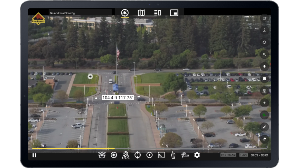
LandForm® X

Overview
PlayPlay
Carry-On MMS
PlayPlay
Geospatial AR
PlayPlay
ISR Toolbar
PlayPlay
Geospatial Telestrator
PlayPlay
Measurement
PlayPlay
Geocoding
PlayPlay
previous arrow
next arrow
Overview
Overview
Carry-On MMS
Carry-On MMS
Geospatial AR
Geospatial AR
ISR Toolbar
ISR Toolbar
Geospatial Telestrator
Measurement
Measurement
Geocoding
Geocoding
previous arrow
next arrow
Shadow

LandForm® X is a comprehensive Mission Management System for Intelligence, Surveillance, and Reconnaissance (ISR) applications offering a variety of Airborne ISR Mission Management capabilities and situational awareness tools. LandForm® X is deployed on an Android tablet, allowing for a “Carry-On” Mission Management solution. With affordable pricing and a user-friendly interface, LandForm® X makes airborne ISR Mission Management more accessible to Tactical Flight Officers and Sensor Operators world-wide.

"Carry-On" Capability

LandForm® X is a “Carry-On” ISR Mission Management System. LandForm® X is deployed to an Android tablet and can operate as a standalone Mission Management System or be paired with a physical keyboard and secondary monitor. Integration with your Mission Aircraft is dependent on a variety of factors, but an example baseline integration utilizes GDS® Tech™ from RAM® Mounts for rapid docking and undocking. 

*Additional accessories (e.g., Video Encoder) may be required depending on your sensor.

LandForm® X | Differentiators

aFFORDABLE

LandForm® X Mission Management System offers a suite of ISR capabilities at an affordable price.

Full Featured

LandForm® X includes a suite of features including: Sensor Control with Geopointing, Moving Map Display, Target List, Mission Packing, Geospatial Augmented Reality, Custom GIS Importing, Geocoding, Cross Cuing, Target Marking, Measurement, Geospatial Telestrator, DVR, and Streaming.

Carry-On

LandForm® X is deployed on an Android tablet and can be simply docked using RAM® Mounts.

User-friendly

LandForm® X was specifically designed to be user-friendly and require minimal training. To do this, the LandForm® X user interface incorporates modern controls and familiar iconography. Additionally, the ISR tools leverage traditional gesture controls and the DVR mimics popular video platforms.

hardware

LandForm® X is currently available on Android and is typically deployed to Samsung Galaxy Tab S7 Series or Samsung Galaxy Tab S8 Series Tablets – although it is capable of running on other Android-OS hardware as well.

Mounting hardware

While the Mission Aircraft configuration and sensor type will drive the ultimate integration, Rapid Imaging has put together a baseline package for mounting LandForm® X in your aircraft. This mounting setup utilizes GDS® Tech™ from RAM® Mounts for rapid docking and undocking and was selected because of its build-quality, ruggedness, ability to delivery power to the tablet, its expandable input/output ports, and it’s ability to function in high-heat and high-vibration environments. As a disclaimer, this is a basic integration setup that may not suit all users.

Sensor COMPATIBILITY

LandForm® X can be utilized with a variety of Sensor payloads, including from popular manufacturers like FLIR, TRAKKA, and WESCAM. Further sensor compatibility is on the development roadmap. If you’re interested in other platforms, please contact us.

FLIR

Gimbal Family:

STAR SAFIRE®

TRAKKA

Gimbal Family:

TC-Series

WESCAM

Gimbal Family:

MX™-Series

LandForm® X | Pricing

isr mission management

Features

Overview
PlayPlay
Carry-On MMS
PlayPlay
Geospatial AR
PlayPlay
ISR Toolbar
PlayPlay
Geospatial Telestrator
PlayPlay
Measurement
PlayPlay
Geocoding
PlayPlay
previous arrow
next arrow
Overview
Overview
Carry-On MMS
Carry-On MMS
Geospatial AR
Geospatial AR
ISR Toolbar
ISR Toolbar
Geospatial Telestrator
Measurement
Measurement
Geocoding
Geocoding
previous arrow
next arrow
Shadow

SENSOR CONTROL with Geopointing

Enjoy full sensor control with geo-pointing for quick and accurate positioning. 

Moving Map

Leverage 4 different viewing options, including a full-screen Moving Map display.

Target List

Manage targets using a Target List that tracks all imported targets as well as inserted targets.

Mission Packing

Import and Export entire missions, including Video, Target List, Audio Files, and more.

Geospatial augmented reality

Display Geospatial Augmented Reality overlays on real-time, full-motion-video – Powered by SmartCam3D®.

Custom GIS Importing

Import custom GIS entities via KMZ and display them as AR overlays on live video at 30+ frames per second.

Geocoding

Perform Forward- or Reverse-Geocoding on live video via 3 geocoding methods.

Cross Cuing

Utilize a cursor anywhere on the live video and see a reactive cursor on the map – OR – utilize a cursor anywhere on the map and see a reactive cursor on the live video. Simultaneously geocode using the active and reactive cursors.

Target Insert

Leverage a variety of target insert tools, including: Point Insert, Polygon Insert, Circle Insert, and Text Insert.

Measurement

Measure distances and areas from real-time, full-motion-video.

Geospatial Telestrator

Free-hand draw on real-time, full-motion-video to create entities with a geospatial context.

TAK server

Leverage a TAK Server with LandForm® X to create a more collaborative operating picture.

DVR (Coming Soon)

Utilize LandForm® X’s integrated DVR for video record and playback.

Streaming (coming soon)

Stream video with a geospatial context to companion Video On Demand platform.