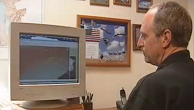
Mr. Geisler is a Marine veteran with over two decades of experience in the UAS industry. Mr. Geisler assisted in the creation of the United States Marine Corps' first unmanned aviation squadron, VMU-2, where he flew the RQ2A Pioneer UAS in support of operations around the world. Today, Mr. Geisler serves as CEO of Rapid Imaging.


Mr. Fiene has eight years of experience in the Unmanned Aircraft Systems industry. As COO of Rapid Imaging, Mr. Fiene oversees operations as well as strategic planning and execution, including program management of over SmartCam3D® licenses utilized by the US Army Unmanned Systems Program.
Rapid Imaging Software, Inc. Founded
January 1, 1985
Rapid Imaging Software, Inc. was originally founded in 1985 by augmented reality pioneer Mike Abernathy.
Pioneering Augmented Reality Development
June 17, 1993

In 1993, Mr. Abernathy demonstrates one of the first successful AR applications, designed to track space debris.
LandForm® Synthetic Vision
March 7, 1995
In 1995, Mr. Abernathy develops Rapid Imaging’s first product, Landform®, a synthetic vision software utilized on manned and unmanned aircraft.
Advanced Flight Visualization Toolkit
March 4, 1998

In 1998, Rapid Imaging was awarded a Phase I SBIR with NASA to develop the Advanced Flight Visualization Toolkit (AFVT). The AFVT project
Integrated Video for Synthetic Vision Systems
March 1, 2001
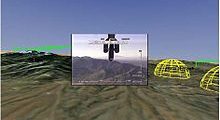
The Integrated Video for Synthetic Vision project aimed to create a unique software technology to seamlessly add real-time video capture to proven
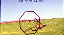
SmarTopo® Intelligent Real-Time Topographic Information Collection System – Phase I
March 12, 2003

In 2003, Rapid Imaging secured a Phase I SBIR with NASA to develop SmartTopo, the first technology designed to provide robotic vehicles
SmarTopo® Intelligent Real-Time Topographic Information Collection System – Phase II
March 2, 2005

In 2005, Rapid Imaging secured a Phase II SBIR with NASA to further develop SmartTopo®.
Advanced Situational Awareness Technology
March 21, 2007

In 2007, Rapid Imaging was awarded a contract to develop Advanced Situation Awareness Technologies (ASAT) to facilitate exploration of the moon surface
SmarTopo® Intelligent Real-Time Topographic Information Collection System – Phase III
March 3, 2012
In 2011, Rapid Imaging secured a Phase III SBIR to commercialize SmartTopo® for the United States Department of Transportation/Federal Aviation Administration in
LandForm® Deployed to Africa
March 5, 2015

In 2015, Rapid Imaging officially released LandForm®, a manned aviation, mission management solution designed to empower sensor operators with enhanced situational awareness.
Rapid Imaging Succession
November 30, 2017

In late 2017, Mike Abernathy, the founder and CEO of Rapid Imaging Software, Inc. retired and the assets of the company were
Rapid Imaging Relocates
March 1, 2018

In March of 2018, Rapid Imaging establishes its new headquarters in Middleton, WI.
SmartCam3D® Plugin for ATAK
March 5, 2019
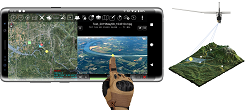
In early March, 2019, Rapid Imaging secured a Phase I SBIR with the United States Air Force to investigate the feasibility of