sUAS Pilot Application

RespondAR is a sUAS Pilot Application providing geospatial augmented reality overlays on live video at 30+ frames per second.  This technology provides enhanced situational awareness to First Responders and other mission personnel by displaying important GIS information on live video while also allowing users to interact with live video in the same ways they would a map – such as dropping a pin to mark a location and geocoding.

Situational Awareness

The RespondAR sUAS Pilot App is powered by SmartCam3D®, Rapid Imaging’s Geospatial Augmented Reality rendering library. The app provides situational awareness by blending geospatial data like the location of roads, boundaries, and Points of Interest, with live video – empowering the viewer to make better decisions – making operations safer and more effective.   

Smarter Cameras

RespondAR® blends geospatial metadata with live video frames to produce video with a geographic context.

Leveraged Assets

RespondAR® allows First Responders to better leverage their sUAS.

Situational Awareness

RespondAR® provides enhanced situational awareness to Pilots, Sensor Operators, and Remote Video Observers.

Mission Assured

RespondAR® is powered by combat-proven technology, SmartCam3D®.

First Responders

RespondAR® is designed for use by a variety of Emergency Response Personnel, including: Fire Departments, Police Departments, State and Federal Emergency Management Teams and others. The app allows First Responders to maintain situational awareness with industry-leading, geospatial, augmented reality on real-time, full-motion-video captured by unmanned aircraft systems. The RespondAR® app provides GIS information including road vectors, street names, points of interest and other map entities, as augmented reality overlays on live airborne video.

Compatibility

RespondAR® is currently available on iOS and is compatible with DJI aircraft. Compatibility across additional manufacturers is on the development roadmap. Available features within RespondAR include the standard features commonly seen in sUAS Pilot Apps, including: Auto Take-Off and Auto-Land, multiple FPV modes, full camera control, and Return-To-Home features – making operations familiar and user-friendly. Additional Augmented Reality features are explained in more detail below.

Tutorial & Features

RespondAR® is loaded with features ranging from Pilot App capabilities to Reverse-Geocoding and Custom KMZ Importing.  To utilize these features, please take a second to check out our Tutorial Video, which explains how to use each of these features, or review the Feature List below.

Pilot app

RespondAR is built on UAS manufacturer SDKs, providing users with a familiar, user-friendly flight experience. Common controls and displays including Auto-Take-Off and Land, flight telemetry, camera settings, compass calibration, controller calibration, battery and GPS status, and more are included within RespondAR.

Geospatial aR

RespondAR provides geospatial augmented reality overlays on live video and combines the benefits of a 2D map display and a Full-Motion-Video display into a single operating picture. Common geospatial entities displayed in the video include street/road vectors, street/road names, Points of Interest, etc.

Overlay Aesthetic

RespondAR provides overlay aesthetic control  allowing end-users to individually select which GIS overlays (e.g. Street Overlays, Points of Interest, etc.) they want to see. Additionally, users can leverage metadata offset controls to adjust Heading, Vertical Field of View, Altitude, and Pitch. 

Drop a pin

RespondAR allows end-users to drop pins within the live video, which assists in a variety of applications when users need to designate specific points of interest.  

cUSTOM gis iMPORT

RespondAR allows end-users to import custom GIS data and display it on live video.  Specifically, RespondAR ingests and displays geospatial data imported via .kmz files.

GEOCODING

RespondAR offers a powerful Geocoding capability allowing users to designate a point in the video and immediately receive the geospatial data (e.g. Lat/Long or Physical Address data) associated with that point on Earth.   

DATA CACHING

RespondAR allows users to cache map and elevation data prior to flight. This allows for the use of RespondAR in remote/offline/low-connectivity/no-connectivity environments.

Frequently asked questions

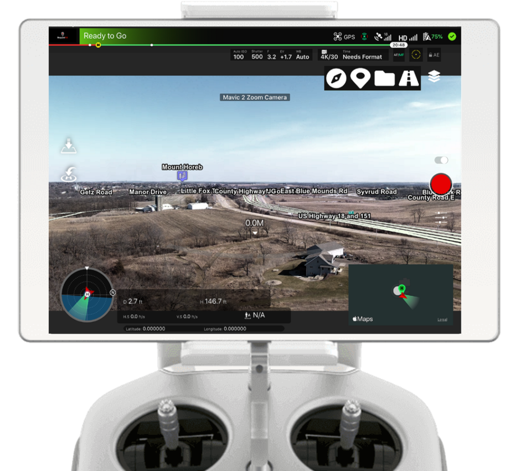
RespondAR is a Pilot application designed for use with small Unmanned Aircraft Systems (sUAS).  The app displays geospatial augmented reality overlays on real-time, full-motion-video from drones. These overlays are similar to what you’d see in Google Maps, including: Road/Street Names, Points of Interest, etc. The RespondAR app also allows users to interact with live drone video in the same ways they would a map (e.g. Drop a Pin to mark a location and Geocoding).  

RespondAR is currently compatible with all modern DJI platforms including the Inspire lineup, Phantom lineup (Phantom 3 and Newer), Mavic lineup, Spark and Matrice Series. Additional non-DJI platforms are on the development roadmap.    

RespondAR is currently supported on iOS.  

RespondAR uses industry-leading Augmented Reality (“AR”) software and is powered by Rapid Imaging’s proprietary SmartCam3D® Augmented Reality Rendering Module.  SmartCam3D® is currently deployed with US Army tactical unmanned systems, embedded within the Universal Ground Control Stations used to fly the Shadow and Gray Eagle UAV platforms.    

RespondAR is currently available on the Apple App Store.  

Geographic Information System Augmented Reality Overlays or GIS AR Overlays are map icons and linework that are superimposed on a live video feed.  Unlike traditional augmented reality, Rapid Imaging’s AR Overlays have a geographic context and can be associated with geographic points in the real-world.  

KMZ Import support allows users to upload their own KMZ files with designated Points of Interest.  This is useful to users who would like to display custom GIS points within live drone video.